14 May 2012
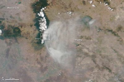
Fig. 1
Satellite image of the eruption of Popocatépetl Volcano
Credit: NASA images By Jesse Allen and Robert Simmon using EO-1 ALI data (top), and Jeff Schmaltz LANCE/EOSDIS MODIS Rapid Response Team, GSFC (lower).
In early May 2012, Mexico’s Popocatépetl Volcano maintained a high level of activity. Nearby seismographs recorded earthquakes accompanied by dozens of explosions each day. The explosions spewed gas and ash from the volcano, and small amounts of volcanic ash fell as far as the suburbs of Mexico City, about 70 km away.
NASA’s Terra satellite captured a natural-color image (Fig. 1) of Popo’s eruption, on 6 May, showing one of the larger exhalations. Fig. 1 reveals the full extent of the volcanic vapors, stretching east and covering the city of Puebla.
References
NASA Earth Observatory
http://earthobservatory.nasa.gov/NaturalHazards/view.php?id=77923
Aymen Mohamed Ibrahem
Senior Astronomy Specialist