| front |1 |2 |3 |4 |5 |6 |7 |8 |9 |10 |11 |12 |13 |14 |15 |16 |17 |18 |19 |20 |21 |22 |23 |24 |25 |26 |27 |28 |29 |30 |31 |32 |33 |34 |35 |36 |37 |38 |review |
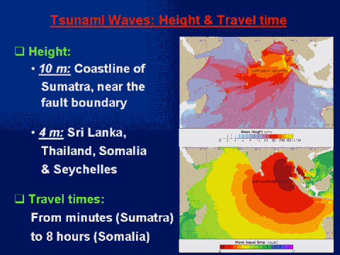 |
"These maps show modeled
maximum wave height (top) and travel time (lower) for the Indian Ocean
Tsunami of December 26, 2004. Although the epicenter of the earthquake that
triggered the tsunami was near the northern tip of Sumatra, the sea floor
shifted along an arc stretching about 1200 km to the north. This shifting
pushes a mass of water across the Indian Ocean." Citation source: |