| front |1 |2 |3 |4 |5 |6 |7 |8 |9 |10 |11 |12 |13 |14 |15 |16 |17 |18 |19 |20 |21 |22 |23 |24 |25 |26 |27 |28 |29 |30 |31 |review |
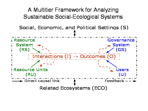 |
At the broadest conceptual level this is a conceptual map.
IT is the starting point for conducting the study of SESs and
presents a simple, very general, nested framework.
Must at least identify a focal level (a small lake, a major
watershed, the Great Lakes, the Pacific Ocean…..)
And the larger and smaller systems it affects or affect it.
At this broad level, one can begin to organize an analysis of how
attributes of a resource system (e.g., fishery, lake, grazing area),
the resource units produced by that system (e.g., fish, water,
fodder), the users of that system, and
the governance system jointly affect (and are indirectly affected
through feedback from) the patterns of interactions and resulting
outcomes achieved at a particular time and place and how these may
affect and be affected by larger or smaller socioeconomic and
political settings in which they are embedded as well as by a larger
or smaller SES.
|