27 February 2011
A satellite image of a volcano in eruption
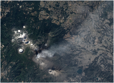
This image, acquired by NASA’s EO-1 satellite, shows the strong eruption of Shinmoe-dake Volcano, located on the Island of Kyushu, Japan.
Credit: NASA
NASA recently published an exquisite natural-color satellite image of the recent violent eruption of Shinmoe-dake Volcano, Kyushu, Japan. The image was taken on the morning of 3 February 2011, by NASA’s Earth Observing-1 (EO-1) satellite. Shinmoe-dake Volcano is 1,421 m high, and is located among the Kirishima group of volcanoes.
The image shows a volcanic plume, colored white and light gray, emanating from the volcano, and stretching eastwards. Gray ash covers the ground southeast of the crater. Interesting volcanic terrains, such as the ice-covered crater lake to the northeast, surround Shinmoe-dake.
On 26 January 2011, the volcano began to spew ash and volcanic bombs, as intermittent explosions shook the surrounding area. Sporadic explosions and ash emissions have been recorded since March 2010, following small precursor eruptions.
Along with the explosive eruptions, a lava dome has developed within Shinmoe-dake’s crater. The lava dome was reported to be 600 m wide, and about 110 m high, on 3 February. It fills most of the summit crater.
EO-1 orbits Earth every 99 minutes, at an average altitude of about 700 km, in a polar orbit passing nearly above Earth’s poles.
References
NASA Earth Observatory
http://earthobservatory.nasa.gov/IOTD/view.php?id=49094
Wikipedia
Aymen Mohamed Ibrahem
Senior Astronomy Specialist