24 February 2011
Dust storm in Egypt
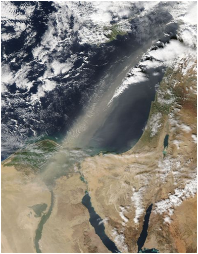
The image shows a dust storm that swirled in Egypt, on 29 January 2011.
Credit: NASA
On 29 January 2011, a dust storm blew out of Egypt and spread into the Mediterranean Sea. NASA’s Aqua satellite captured this natural-color image of Egypt the same day.
Stretching for hundreds of kilometers, the dust plume extended from Egypt across the Mediterranean Sea, dissipating off the Lebanese coast. Coming from Egypt’s interior, the dust swept Cairo and the Nile Delta. Sources of the plume are not shown in this image, but the dust may have originated in Egypt’s Western Desert.

An artist’s concept of the Aqua satellite
Credit: NASA
NASA monitors the environment with a group of sophisticated satellites. The Aqua satellite carries onboard a suite of sensors, specially designed for studying water on land, in the oceans, and in the atmosphere. It was launched into space on 4 May 2002, aboard a powerful Delta II rocket. Aqua’s mass is over 3,000 kg! Aqua circles Earth every 98 minutes, at an average altitude of about 700 km. Its orbit is polar, a type of orbit that passes over or near Earth’s poles. The name Aqua comes from Latin word for water.
References
NASA Earth Observatory
http://earthobservatory.nasa.gov/NaturalHazards/view.php?id=49034
Wikipedia
Aymen Mohamed Ibrahem
Senior Astronomy Specialist