The advent of aviation enabled us to discover a long-hidden treasure of ancient civilization that was impossible to identify from ground level. We mean the amazing Nazca Lines—identified by pilots flying over Peru in the late 1920s—which are now on the UNESCO World Heritage Sites.
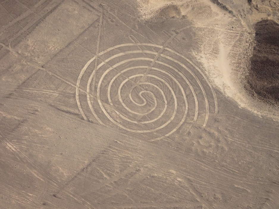
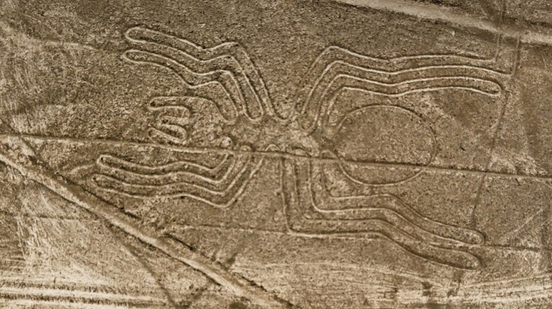
The Nazca Lines, including hundreds of straight lines, geometric designs, and pictorial representations, extend over 500 km2 across the arid Nazca Desert in southern Peru. Due to the dry climate and isolated location, they have remained intact for about 2000 years.
The Lines are believed to date back to the ancient Nazca civilization that flourished between 200 BCE and 600 CE, for many of the depicted figures also appear on Nazca ceramics and textiles. The massive scale of the designs and the huge area they cover suggest they were made over several centuries ago. Yet, how did the Nazca make them?
The surface of the Desert floor is covered by a layer of iron oxide-coated rocks, which gives it a quite dark color compared to the layer beneath. As such, they removed around 30 cm of surface rock to make their line drawings, allowing the light-colored ground below to contrast.
The purpose of these geoglyphs have been subject to dispute among researchers for long decades, not to mention the radical hypothesis relating them to aliens and supernatural powers. Peruvian archaeologist Toribio Mejía Xesspe was the first to propose the Nazca Lines to the scientific world in 1927, but not much of her work was reported. In the late 1930s, American historian Paul Kosok investigated the lines from the ground and air, concluding that the geoglyphs had astronomy-related purposes. He conducted measurements related to the Sun alignment with one of the lines he studied, describing them as “the largest astronomy book in the world”.
German researcher María Reiche, known as the Lady of the Lines, continued to study them for 40 years; she maintained that they serve astronomical and calendrical purposes. She also hypothesized that the pictorial representations of animals corresponded to some star constellations, and that the lines were used to observe the movement of celestial bodies. Reiche believed that the Lines enabled the Nazca to identify the seasons, provided them with important information for agriculture, and helped them know directions.
Check out these videos to know more about the Nazca Lines and the Lady of the Lines.
Kosok’s and Reiche’s theories were widely accepted until the 1970s, when a group of American researchers, including astronomer Gerald Hawkins, started studying the Nazca geoglyphs. Their counterargument was that most of the Lines do not point to areas where the most significant astronomical activity takes place. Moreover, the Nazca Desert is not an ideal location for making astronomical observations; the area is often foggy, and hence, vision is so difficult before sunrise and after sunset.
More recent research connected the Nazca Lines to water, the most valuable commodity in the arid Peruvian Desert. In the 1990s, American researcher David Johnson conducted a study, in collaboration with researchers at the University of Massachusetts, proposing that the Lines marked underground water resources. For example, the circles indicate a nearby water spring, and the hummingbird indicates a large well. Although the theory was interesting, it lacked sufficient evidence for it was not applicable to many of the drawings.
Another approach, which is more widely accepted nowadays, also connects the Lines to water; not as a means to find it, but rather as part of a ritual. Explorer Johan Reinhard proposed that they “led to places where rituals were performed to obtain water and fertility of crops”. Researcher Anthony Aveni agrees, claiming that the Nazca people made their lines as an effort so that the gods would send the much-needed rain. The animal depictions also symbolized the need for water; the sea birds referred to the ocean, and the monkey referred to the water-rich Amazon forests.
Our understanding of the Nazca Lines will continue to evolve and new discoveries will show up as research goes on. In 2018, archaeologists discovered over 50 new geoglyphs in the region, and they are employing advanced drone technologies to map the area in unprecedented detail. It is worth mentioning that the Nazca Lines are not only an attraction for scholars, but also for tourists who book flights to fully appreciate the landmark from the air.
References
ancient-origins.net
history.com
nationalgeographic.com
people.umass.edu
peru-explorer.com