31 May 2007
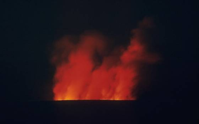
An Eruption of Mona Loa Volcano, Hawaii
Credit: USGS
Volcanoes are among nature's most violent, and most dangerous phenomena. Predicting volcanic eruptions is among the greatest scientific challenges. Using a state-of-the-art satellite imagery technique, researchers can more precisely predict volcanic activity, bringing them closer to spotting where a possible eruption may occur.
In a new study, entitled “Stress Control of Deep Rift Intrusion at Mauna Loa Volcano, Hawaii” a research team applies satellite radar imagery to study volcanic activity in Hawaii. The study was published in the 18 May 2007 issue of the journal Science.
Aided by this powerful new research tool, scientists can more precisely forecast spots of activity, providing crucial information to improve warning systems and hazard assessment of populated areas near volcanoes.
From 2002 to 2005, the team of researchers, led by Dr. Falk Amelung of the University of Miami Rosenstiel School of Marine and Atmospheric Science, applied a sophisticated radar technique to obtain images of the ground deformation related to volcanic activity.
They detected distinct patterns of magma activity associated with rift zones, long narrow fractures in the Earth's crust from which lava erupts. Magma is molten-rock located beneath Earth's crust. The researchers believe that Magma conduits were excavated by past eruptions and earthquakes, allowing magma to flow. Magma accumulated in the rift zones, pushed the flanks apart, stimulating stress in the area that ultimately erupts.
“We are able to infer very precisely where magma accumulation occurred and we have an explanation why it occurred in this particular location,” said Amelung. “We now have a good idea where the next eruption is most likely to occur. This technique can be employed on other large volcanoes to better forecast eruption locations.”
Researchers are studying Mauna Loa Volcano because it is the largest volcano and one of the most active volcanoes on Earth. Some volcanic phenomena, such as lava flows and flank collapse, can pose a threat to populated areas. Also, dome collapse may trigger tsunamis.
This research technique can be applied to monitor powerful volcanoes, in many regions of the world.
The study was funded by NASA's Earth Science program and the National Science Foundation Geophysics program.
Further Reading
Tracking a Hot Spot
http://www.rsmas.miami.edu/pressreleases/20070517-mauna-loa.html
Aymen Mohamed Ibrahem
Senior Astronomy Specialist