20 May 2007
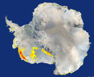
NASA's QuikScat satellite detected extensive areas of snowmelt, shown in yellow and red, in west Antarctica in January 2005.
Credit: NASA-JPL
In a recent study, based on data acquired by NASA's QuikScat satellite, a team of scientists found clear evidence that extensive areas of snow melted in west Antarctica in January 2005, due to warm temperatures.
This is one of the most significant Antarctic ice melt during the past three decades. The total area of the affected regions is nearly equal to that of California.
The team leaders are Son Nghiem of NASA's Jet Propulsion Laboratory (JPL) and Konrad Steffen, Director of the Cooperative Institute for Research in Environmental Sciences at the University of Colorado.
The team measured snowfall accumulation, and melt in Antarctica and Greenland from July 1999 through July 2005.
Interestingly, some of the observed melting occurred in regions, far inland, at high latitudes and at high elevations, where melt had been considered unlikely.
Evidence of melting was found as far as 900 km inland, or about 500 km from the South Pole, at over 2,000 m above sea level.
Measurements show that maximum air temperatures, at the time of the melting, were unusually high, and remained above melting for approximately one week.
"Antarctica has shown little, to no warming, in the recent past with the exception of the Antarctic Peninsula, but now large regions are showing the first signs of the impacts of warming as interpreted by this satellite analysis," said Steffen. "Increases in snowmelt, such as this in 2005, definitely could have an impact on larger-scale melting of Antarctica's ice sheets if they were severe or sustained over time."
QuikScat's scatterometer instrument emits radar pulses toward the ice sheet surface, measuring the reflected pulses. When snow melts and then refreezes, it changes to ice, just as ice-cream crystallizes when it is left out too long and is then refrozen. QuikScat can distinguish this characteristic in the snow cover and can map on a continental scale the extent of strong snowmelt and the subsequently formed ice layer. Ground-based measurements confirm the satellite results.
The melt observed in 2005 was intense enough to form an extensive ice layer when water refroze. However, the melt duration was not long enough for the melt water to flow into the sea.
"Water from melted snow can penetrate into ice sheets through cracks and narrow, tubular glacial shafts called moulins," Steffen said. "If sufficient melt water is available, it may reach the bottom of the ice sheet. This water can lubricate the underside of the ice sheet at the bedrock, causing the ice mass to move toward the ocean faster, increasing sea level."
Variations in the mass of Antarctica's ice, world's largest mass of freshwater, are crucial for studying global sea level rise. Also, large amounts of Antarctic freshwater flowing into the ocean could affect ocean salinity, currents and global climate.
Nghiem said while no further melting had been detected through March 2007, more monitoring is needed. "Satellite scatterometry is like an X-ray that sees through snow and finds ice layers beneath as early as possible," he said. "It is vital we continue monitoring this region to determine if a long-term trend may be developing."
Further Reading
Measuring Ocean Winds from Space
http://winds.jpl.nasa.gov/index.cfm
Aymen Mohamed Ibrahem
Senior Astronomy Specialist